📖
Cerulean Sonar Docs
Docs DirectoryStore
Ethernet ROV Locator
  • ROV Locator
  • Overview
  • General Specifications
  • Quick Start for BlueROV
  • Fundamentals Useful to System Designers
    • Sound Reflection and Absorption
    • Multipath
    • Ping Length
    • What to Do About Multipath and Other Issues
    • Clock Drift Expectations
    • Accuracy Expectations
      • Accuracy Test: Topside GPS
      • Accuracy Test: 110 Meter Slant Range
      • Accuracy Test: 295 Meter Slant Range
    • Operation in a Pool
  • Configuring the ROVLe
    • Finding the Configuration Web Page
    • Example Configuration Web Page
    • Live Status Page
    • Setting Device Type
    • Setting the Static IP Address
    • Setting the Fallback IP Address
    • Setting the MAVLink REST Server Parameters
    • Setting the Secondary (GNSS) MAVLink Interface
    • GPS/GNSS Forwarding (Re-tweeting)
    • Magnetic Declination
    • CIMU Calibration Offsets
    • Speed of Sound
    • GNSS Antenna Mounting Rotation
    • Output Messages
    • Configure Simulation
  • System Variants
  • Autosync
    • Autosync Mission Scenarios and Mission Suitability
    • Autosync Availability
    • Autosync GPS/GNSS Output
    • ROVL Channels (Autosync only; Operating Multiple Units in Proximity)
  • Communicating With the ROVL
    • Serial Parameters
    • The Ethernet Interface
      • Tips on How to Find the IP Address Assigned to Your Ethernet Adapter
      • Blue Robotics Discovery Protocol (Ethernet Only)
    • Packet Format
    • Messages from ROVL to Host
      • $USRTH Receiver-Transmitter Relative Angles Message
      • $USTLC Target Location Message
      • $USINF/$USTXT Information Message
      • $USERR Error Message
      • $USNVM Non-Volatile Memory Message
    • Messages from Host to ROVL
      • NMEA-Format Messages to Receiver
      • Valid Commands from Host to ROVL, Serial and Ethernet
      • Valid Commands from Host to ROVL, Ethernet Only
        • Command: DHCP
        • Command: FALLBACK-ADDRESS
        • Command: IP-ADDRESS
        • Command: HOST-ADDRESS
        • Command: MAVLINK-ADDRESS
        • Command: MAVLINK-AUTO-ORIGIN
        • Command: MAVLINK-SYSID
        • Command: PAUSE
        • Command: RESUME
        • Command: RETWEET-GPS
        • Command: RETWEET-GPS-ADDRESS
        • Command: RETWEET-message
        • Command: SEND-ROV-POS-TO-MAP
        • Command: SEND-TOPSIDE-TO-MAP
        • Command: SEND-USRTH
        • Command: SEND-USTLC
        • Command: UNICAST-TO-ME
  • Cerulean Inertial Measurement Unit (CIMU)
    • CIMU Calibration Background
      • CIMU Magnetometer Calibration
      • CIMU Accelerometer Calibration
      • CIMU Gyro Calibration
  • Operating and Accuracy Considerations
  • Multi-Unit Operation (Swarms)
    • Multi-Unit 1:1
    • Multi-Unit 1:2
    • Multi-Unit 2x1:1
  • ROVL Mounting
    • ROV/Deepside Mounting
    • Topside Mounting
    • Simple Topside Deployment Fixture
  • ROVL Wiring
    • Standard Cabling Options
    • ROVL-e PC Board Internal Connections
      • JST-GH Connector Pin 1 Identification
      • Ethernet/Power Connections
      • Serial Connection
      • USB Connection
      • GNSS Compass Main (4-pin) RS-232 Connection
      • GNSS Compass RTK (2-pin) RS-422 Connection
    • Electrical Noise
  • Connecting and Powering Your ROVLe Ethernet Receiver or Transceiver
    • Example Power Injectors
    • Data Connection
    • Example Power/Wi-Fi Setup for Remote Usage
    • Battery
  • Mounting Dimensions
    • Mk II Receiver with Omnitrack Top
    • Transmitter/Transceiver/Receiver with Standard Top
    • Mk III Transcceiver
    • ROVLe Omnitrack Top
    • ROVLe Standard Top
    • Example Mounting Scheme with 3D-Printed Bracket
  • ROVL Coordinate Systems and Angles
    • Definitions
    • NED or "Compass" vs. ENU or "Math" Angles
    • Math to Compass Frame Conversions
    • Transducer Down Orientation
    • Transducer Up Orientation
    • Receiver/Transceiver Orientation Frames
    • Best Operating Envelope
  • Appendix: Math for Computing Remote Latitude/Longitude
    • Receiver & GPS at Topside and Transmitter Deepside
    • Transmitter & GPS Topside and Receiver Deepside
  • Appendix: Factory Usage Command Set
  • Troubleshooting
    • How to Tell if Your Mk II Receiver is Working
    • How to tell if your Mk II Transmitter is working
    • What to do when you find an unresolvable problem when troubleshooting
  • Copyright
Powered by GitBook
On this page
  1. Appendix: Math for Computing Remote Latitude/Longitude

Receiver & GPS at Topside and Transmitter Deepside

PreviousAppendix: Math for Computing Remote Latitude/LongitudeNextTransmitter & GPS Topside and Receiver Deepside

Last updated 1 month ago

This is the canonical, or "normal" configuration.
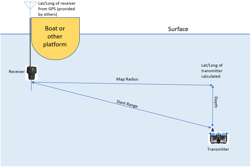
latitude_rx :: from GPS co-located with receiver (in degrees that include minutes and seconds)

longitude_rx :: from GPS co-located with receiver (in degrees that include minutes and seconds)

bearing :: true bearing (not compass bearing) from $USRTH message

elevation :: elevation from $USRTH message

slant_range :: slant range from $USRTH message

depth (best, if available) :: from ROV depth sensor (minus depth of receiver unit)

depth (use if ROV depth sensor not available) = abs( sin(elevation) x slant_range ) [note 1]

map_radius = cos(elevation) x slant_range

CE = 40,074,000 m // Circumference of earth in meters

lat_m_per_deg = CE / 360 // meters per degree of latitude

long_m_per_deg = lat_m_per_deg x cos(latitude_rx) // meters per degree of longitude [note 1]

latitude_tx = latitude_rx + (sin(bearing) x map_radius / lat_m_per_deg) [note 1, 2]

longitude_tx = longitude_rx + (cos(bearing) x map_radius / long_m_per_deg [note 1, 2]

Note 1: Remember, most computer functions require you to convert degrees to radians

Note 2: the signs of the degrees as noted above are needed in the computations

Note 3: longitude degrees that are West are negative, East are positive. Latitude degrees that are North are positive, South are negative.